GEOLOGICAL WORKS OF RIVER - FLUVIAL CLASSIFICATION SYSTEM - ENGINEERING GEOLOGY (StudyCivilEngg.com)
GEOLOGICAL WORK OF RIVER
FLUVIAL CLASSIFICATION SYSTEM
- Fluvial geomorphology is very important in major Civil Engineering operations. The most fundamental landforms seen on the earth's surface are developed by fluvial action, though other processes also substantially contribute to their modification and development.
- An understanding of applied fluvial geomorphology, including quantitative study of sediment load, is essential where a dam is to be constructed across a river valley as a part of hydroelectric and irrigation projects. The study is useful in calculating the life of a reservoir. In rare cases, the river may flood, overflow their banks and an abnormal sediment load may be deposited over their flood plains.
- Here, an understanding of artificial channelization may be beneficial which helps to reduce the problem by speeding up the escape of the flood water. The required information is derived from quantitative estimations of discharge variations in rivers, the nature and amount of sediment load etc.
- The capacity of a river to carry sediment load and to erode its channels, laterally as well as vertically, is evaluated by the amount of energy it possesses.
- A river has a potential energy controlled by the amount of water present (volume) and the head of the water (vertical distance above sea level). The kinetic energy (an energy of movement) generated by the river is evaluated by the flow of water and its velocity i.e. discharge. Thus, an increase in the discharge of water and its velocity leads to an increase in river energy. Rivers may show substantial spatial as well as temporal variations.
FLUVIAL CLASSIFICATION SYSTEM
- Rivers normally flowing into channels cut either into bedrock or in alluvial (recent) sediments. Rivers in bedrock tend to follow a stable course while those in alluvium have a strong tendency to change their position and behaviour. Failure to understand the natural behaviour of alluvial river systems can lead to damaging effects particularly if artificial changes are introduced in the system.
- Bedrock channels are likely to be much more irregular than alluvial channels. Whether in alluvium or bedrock, the Thalweg, or line connecting points of maximum water depth in a general downstream direction along the channel is seldom straight.
- In humid regions, rivers are called Effluent as they receive water also from groundwater. Rivers in arid regions generally lose water to ground in addition to losing it by evaporation and they often dry up completely without reaching the sea. They are called Influent streams.
- The shape of river and channel segment is used to describe different terms. Some segments are straight in plan view. Sinuous channels develop in bedrock and alluvium either by rounding the corners of zigzag channels or alternately eroding and depositing sediment as pools and riffles along former straight reaches. The sinuous channels are called meanders. Rivers that carry large amount of coarse sediment construct midstream bars at frequent intervals and divide into numerous intersecting and shifting channels, called as braided or anastomosing.
FLUVIAL EROSION
- Erosion by a river or a stream is the process of continuous removal of weathered material from in-situ.
- The most common process of stream erosion is mechanical abrasion or corrosion. The rate of corrosion depends on the volume of water, the gradient, hardness and softness of bedrock. The coarse disintegrated particles of hard rock are rolled and dragged along the channel floor, slowly removing away exposed rock outcrops.
- Pot holes are often created in the beds of the fast flowing rivers due to strong eddy motions by swirling action of pebbles. The sheer hydraulic power exerted by rapid river flow, referred as pot-hole drilling may also be responsible for shattering of bedrock in the channel. The process becomes easier if joints and bedding planes are widened by localised corrosion or chemical attack.
- Erosion by a river or a stream is influential in three interactions; viz vertical downcutting, erosion and headward erosion.
Vertical Downcutting
Vertical downcutting is peculiar of the fast flowing rivers that transport a large bed load. The bed load is used to abrade and pot hole the channel floor, which leads to the formation of deep narrow gorges. However, river water cannot continue to flow when there is no slope and there is also a limit below which a river cannot excavate its own bed. Thus, no further conversion of potential energy to river work is possible. The ultimate base level is the sea level into which the rivers must flow. But for smaller streams, temporary base levels are created by lower limiting planar surfaces produced by lakes, resistant rock masses etc.
Lateral Erosion
Once the temporary base level is attained, the kinetic energy of the river is used for lateral excavation causing bank erosion. However, the role played by weathering and slope transport in the process of valley widening is substantial. As a result of these interactions meanders or sinusoidal bents are developed.
Headward Erosion
Headward erosion is prominent where river profile is steep. It is associated with waterfalls where an alternate sequence of hard and soft rock is observed. Thus, on steep end valley sections, the rapidly flowing water increases the rate of erosion with the result that steepened section migrates upstream.
In the case of waterfalls, erosion is concentrated at the base of the fall and may involve sudden burst of trapped air bubbles. This process is known as cavitation. This leads to retreating of the fall and periodic collapse of hard rocks so that in course of time, the fall may be abandoned.
FLUVIAL TRANSPORT
The theoretical maximum load that a stream can transport is labelled as its capacity; while, competence is the measure of a river's ability to transport a maximum grain size of disintegrated particles. It depends on the factors like velocity, the shape and size of particles, temperature of water etc. The weathered material (disintegrated and decomposed) is transported in three forms
Bed Load: Bed load is often a permanent load situated in the river channel. It includes the gravel and large size fragments, transported close to the channel floor by rolling or sliding.
Suspension Load: Clay, silt and sand particles transported during moderate/high flow, are called as suspension load.
Solution Load: The decomposed material available in solution or colloidal mixtures is called dissolved or solution bed.
FLUVIAL GRADATION
- The concept of stream gradation is controlled and influenced by many factors including discharge, sediment load, base level, channel width, depth, bed roughness etc. The fluvial system is said to be graded if the stream channel system adjusts its gradient and attains an average steady state of operation for a measurable period.
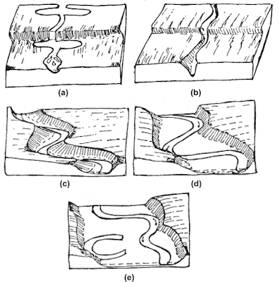
- The system is then said to have achieved an equilibrium state of operation. The equilibrium may be achieved in a process of a gradational step. Thus, the concept of a river in graded system may be visualised by first imagining an ungraded river that flows over a tectonic landscape, newly raised from the other normal land or from the floor of the sea (Fig (a)). Rainfall varies over the landscape, water flows down-slope along easy water carrying paths. Drainage networks are eroded and valleys are broadened by mass wasting on slopes along the deeper channels (Fig (c))
- In this way, the initial channel originates and begins its travel towards the sea. The gradation processes may be marked in the smoothness of river profile. Irregularities in profile are related to the presence of lakes, rapids, falls or beds of hard rock which provide temporary base levels so that profile flattens off on approaching these features, and then steepens again below them.
- Here, the velocity of a river or a stream rapidly increases and thus abrasion of bedrock becomes intense. As a result, falls are cut back and the rapids are trenched, while the lakes are filled by sediments. As a continuous process, the lakes disappear and falls are transformed into rapids while the rapids are reduced to a gradient of minimum irregularities.
- Simultaneously, tributaries are also being introduced into the land mass, excavating the drainage area and converting the original landscape into a fluvial land form system.
- In the initial stages, the stream's energy is utilised in excavating the floor (downcutting) so that very little or no debris accumulates in the channel. However, continuous excavation contributes to an increasing supply of rock debris to the channels. Thus, there comes a stage when the supply of bed exactly matches the stream's capacity for transport. This stage is called the graded condition.
- After attaining this stage, the stream continues to excavate on the outsides of the bank (lateral erosion) and the first indication of having attained a graded condition may be visualised in the development of a flood plain valley.
- On the outer side of a bend, the channel shifts laterally into a curve of a large diameter and erodes the outer bank.
- On the inside of the bend, the alluvium accumulates in the form of point bar deposits
- As a continuous process, the flood-plain valley is widened and meanders or sinusoidal bends are developed
- Occasionally they produce cut-offs, leaving crescentic mort or ox-bow lakes
- Because of flood plain development, the deeper valley gradually disappears and forms an open valley with soil covered slopes.
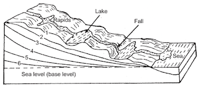 |
| Evolution of a Stream |
- The profile, if plotted, of such a stream, is referred as a graded profile. However, the profile may not be very smooth, if considered the effects of major tributaries which cause abrupt increases in the discharge and load from point to point along the main stream.
- Thus, at each confluence point, the profile of a graded stream is segmented. Irregularities of profile may often be due to a distinct change in bedrock from place to place, for example, a sandstone shale sequence. Theoretically, the goal of the erosion process is to reduce land mass to penultimate base level. After a time span of millions of years, the land surface is reduced to an undulating surface of minimum elevation known as Peneplain.
- Thus, the history of the fluvial system from the initial period to peneplain surface, is considered, in three stages.
- The youth stage of a river system is characterised by steep gradients giving rise to gorges or narrow, steep sided valleys water falls and rapids are common and the river profiles are not in equilibrium. The rapidly flowing streams consume their energy in the process of excavation and thus there is no flood-plain.
- In the maturity stage, the gradient is moderate and the valley is deeper and wider. The stream is in equilibrium and said to possess a flood-plain along with meandering curves
- In the old stage, the gradient is still lowered; the valley is widened and lateral cutting by the migrating meander belt becomes the main erosional process. A broad flood plain, characterised by large meanders, braided or anastomosing stream, is formed
- Irregularities are minimum and thus the condition of base levelling or peneplanation is almost achieved.
FLUVIAL MORPHOLOGY
Every river is seen as a three dimensional body. In order to understand the concept of river evolution it is necessary to explain the elements of channel geometry i.e. plan view, cross section and longitudinal profiles; and to understand their mutual dependence. They are also part of an 'interconnected system' which is further controlled by the external factors (natural base factors, tectonics, lithology, climate), discharge and sediment load.
Plan View: Three channel patterns are recognised: straight, meandering and braided. In nature, geometrically straight channels are rare. Channels are thus called straight if they exhibit a very small river evolution over a certain distance. Two main factors govern the straight nature of a channel: a steep gradient and a narrow course caused by geological and morphological influences. Elongation due to steep gradients is typical in geologically young mountain ranges and tectonically active regions. In small scale maps minor morphological features are suppressed to an extent that the whole river gives the impression of a straight course.
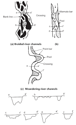 |
| River Channel Patterns |
Meandering River Channels
- Sinuous river channels are usually referred as meanders. More precisely a meandering stream is the one whose channel alignment consists essentially of pronounced bends with deep pools in the outer side and shallow crossing in the short, straight reach connecting the bends. The thalweg flows from a pool through a crossing to the next pool, forming the sinuous curve of a single meander loop.
- The pool tend to be triangular in section with point bars located on the inside of the bend. In the crossings, the channel is more rectangular with greater width and shallower depth. At low flows the local slope is steeper and velocities are greater in the crossing than in the pool. At low stages the thalweg is located very close to the outside of the bend. At higher stages the thalweg tends to straighten. It moves away from the outside of the bend and encroaches on the point bar partially. With increase in time meanders widen their loop at various rates and move downstream.
- The latter process is described as migration. The phenomena of widening and migration can be developed separately but usually they are interlinked. Migration to a large extent, is controlled by erosional resistance of the bedrock.
- When the meander loops approach each other due to their lateral erosion, a cut-off is established at the contacts that leads to the establishment of ox-bow lakes
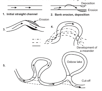 |
| Development of ox bow lake |
- Each cut-off shortens the course and thus leads to an increase of the gradient in the area which proportionally increases the energy potential of the river and accelerates the widening of the loops
- Meandering pattern is very common in alluvial streams. In tortuous meandering channels, bends are deformed and smoothness which is typical of meander bends is absent. Irregular meanders consist of a pattern of low amplitude and wavelength superimposed on a larger pattern. It is suggested that smaller meanders may be related to the periods of low perennial flow, while the larger owe their origin to the mean annual flood.
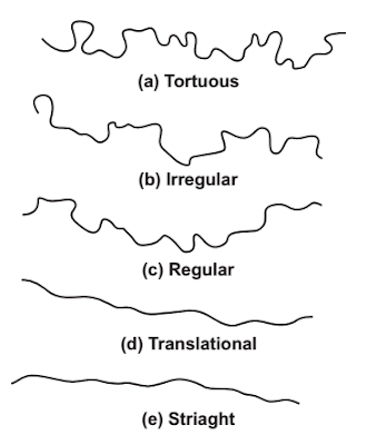 |
| Rivers in Alluvium, classification based on their Geometry |
The regular pattern shows regular waveform in plan. The transitional pattern is characterised by very flat curves and the straight pattern has minor bends without any irregularity.
Braided River Channels:
This are commonly encountered in areas with strong bed load transport. The river is split in numerous diverging channels which reunite again and change their appearance with every major flood. While one channel is being filled up, the water scours a new path until the next flood leads to its starvation and widens another. The two primary factors that may be responsible for the braided condition are overloading and steep slopes. Disturbances of a braided reach can be caused by variation in one of these basic parameters.
If changes in the supply of bed load are reduced for any reason, braided river quickly lose their characteristic features. Degradation starts to prevail and the network of braided sections is replaced by a stretched channel that cuts itself into the bottom and causes the former channel to fall dry.
Longitudinal Sections
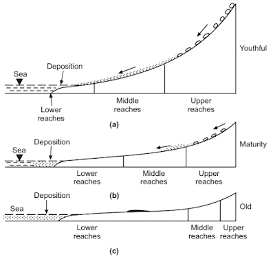
- The longitudinal profile of a river is one of the most important morphological element, to mark the earth's surface. Their development controls the morphological character of a landscape. The longitudinal profile represents its gradient of the bottom at each point as a reaction to tectonic, lithological and climatic factors. The gradient in the upper reaches is steep, it decreases gradually downstream and is very low at the base for the erosion or at sea level. Thus, every longitudinal profile is divided into upper, middle and lower reaches
 |
| Stages of Denundation |
- Erosion is predominant in upper reaches, transportation in the middle and accumulation in the lower reaches. It is seen from the below figure that slope and distance of longitudinal profile varies consistently with stages of denudation. This roughly corresponds with the youthful, maturity and old stage of a river system.
- In case of a river in youthful stage where erosion is predominant, its slope is steep and distance of upper reaches is much more than that of middle and lower reaches. In the maturity stage, slope is gentle and distance of middle and lower reaches is more than upper reaches. In the old stage elevation difference between source and month is not significantly large. Lower reaches cover about 80% of the profile compared to middle and upper reaches.
Cross-sectional View
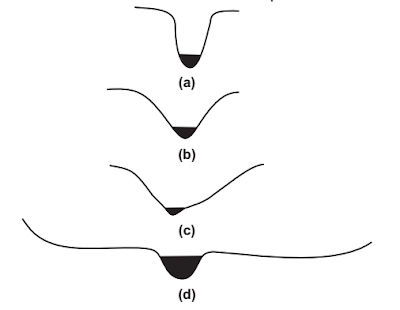
Cross-section on rivers is a direct expression of the controlling forces of erosion and transportation. In every phase of development, a river will show the appropriate cross-sections. Direct or close relationship to the river is developed only for the gorge, the canyon or the V shaped valley. Lateral erosion gradually becoming predominant. This gives rise to valley widening.
In a gorge or V shaped valley of narrow width, the river occupies the entire width of the valley, the bed is rocky and covered by large boulders. While U shaped broad valley indicates that the river has developed its flood plain and except during the flood-time, the river occupies deepest portion of the valley. A characteristic of many low land river is development of levees.
FAQs COVERED IN THIS POST
What are the Geological Works of River?
What is Fluvial Erosion?
What is Fluvial Gradation?
What is Fluvial Transport?
What is Fluvial Morphology?
What is Fluvial Classification System?
What is Meandering River Channel?
What is Braided River Channel?
Describe Evolution of the Stream
Classification of rivers in Alluvium based on their geometry
Development of ox bow lake
What are the river channel patterns?
RELATED POSTS
- SURVEYING - STUDY ONLINE
- BUILDING MATERIALS AND CONSTRUCTION - STUDY ONLINE
- FLUID MECHANICS - STUDY ONLINE
- SOIL MECHANICS - STUDY ONLINE



Post a Comment