EROSIONAL LANDFORMS & REJUVENATION (GEOLOGICAL WORK OF RIVERS) - ENGINEERING GEOLOGY (StudyCivilEngg.com)
GEOLOGICAL WORK OF RIVER
EROSIONAL LANDFORMS & REJUVENATION
SUBJECT : ENGINEERING GEOLOGY
EROSIONAL LANDFORMS
During the process of erosion, the river may give rise to a number of landforms developed under variable conditions. Origin of these landforms is influenced by many factors including composition and structure of rocks, pre-existing morphology, climate, eroding agent etc. Major landforms are as below:
Waterfalls
Waterfall and rapids are amongst the most important fluvial landforms and are potential sites for hydroelectric power generation. A waterfall is a site where water falls vertically; a cataract is a step like succession of waterfalls; while rapids are short steep slopes in the long profile of a stream. These normally occur due to three reasons
- Those resulting from differential erosion of rocks with varying resistance.
- Those which results from deposition in a stream channel
- Those caused by vertical slips in the longitudinal profile
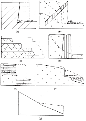
Horizontal or moderately dipping sequence may contain a resistant layer; such as sandstone, dyke. The resistant rock then forms a cap rock while weaker underlying beds are rapidly eroded. Step falls develop in rocks with a more uniform erodibility where undercutting occurs along individual bedding planes [Fig.(b) and (c)]. Single falls also occur where vertical beds juxtapose rocks of varying resistance e.g. dyke [Fig. (d)]. Falls are also observed in an area of tectonic uplift [Fig. (g)], faulting [Fig. (e)], steep coast [Fig. (f)].
 |
| Causes and controls on the location of waterfalls |
Successive positions of waterfalls are indicated by numerals. Please note that the plunge pools and the tendency to undercut the cap rock in the uppermost diagrams.
Rates of waterfall recession are very variable. Retreat is frequently along lines of weakness (faults, joints). In sedimentary rocks, the dip may also control the lifespan of a waterfall, as falls in beds dipping upstream will be gradually reduced in height while horizontal or downstream dipping beds will maintain the falls. It can be said that elimination of waterfall is aided by high velocity, erosive capacity, cavitation and undercutting of cap rock.
Structure Controlled Landforms
The typical structure controlled landforms shown in below figure are best seen in sedimentary rocks terrains.
 |
| Structured Controlled Landforms |
If an alternate sequence of tilted hard and soft rock is observed, in such a case after erosion, the outcropping edge of a resistant rock will form an escarpment, while the dip slope is parallel to stratification. In case, the hard resistant rock is horizontal and caps a broad flat topped table land, it is known as Mesa. However, if the diameter of cap rock is lesser than the elevation of a hill above the adjoining areas, the hill is known as Butte.
A cuesta is an asymmetrical hill with a gentle dip slope and a steep escarpment slope, while a hogback is an symmetrical hill with the amount of dip slope comparable with the amount of escarpment slope. In case of flat irons, the dip slope is steeper than the escarpment slopes.
Generally, the escarpment streams are steep and short with high gradient. On the other hand, the dip slope streams are gentle and long with low gradient. As a part of continuous process, a stream flowing along the low elevation between an escarpment slope and dip slope, will migrate along down dip direction. Similarly, weathered material may easily be transferred along steeper escarpment slope than along gentler dip slope. Thus, the entire ridge and valley system migrate in downward as well as lateral direction. The process is known as homoclinal shifting.
River Capture
Stream capture or piracy is associated with growth of main river and subsequent streams. It is a very common phenomenon controlled by variable geological factors, more likely in areas of weakened and rapidly erodable rock. Below figure, suggests how this process could occur. Diagnostic features of river capture include
 |
| River Capture |
- The sharp change of river course at the site of the diversion; known as the elbow of the capture.
- The presence of a col marking the course of the diverted stream prior to the capture, known as the wind gap.
- The misfit geometry of the beheaded stream, which is normally abnormal for the valley it occupies.
The effects of a capture on the hydraulic geometry of the capturing stream and the beheaded stream can be typical. It is observed that the capturing stream has a relatively steep longitudinal profile in a low order tributary stream at the capture, whereas the beheaded stream has a gentle low profile.
REJUVENATION
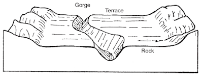
In case rejuvenation occurs in a peneplain area, a steep sided Narrow Gorge on either side of which lies the former floodplain is developed above the present channel depth. The flat surface characteristic of flood-plain is known as Rock Terrace.
 |
| Incised or Entrenched Meander |
Similarly, where the graded stream had developed meanders on a broad flood plain, the process of uplift responsible for rejuvenation causes the meanders to begin active erosion again and excavate its own flood-plain to form entrenched meanders or incised meanders. Another possible indication of rejuvenation is presence of waterfall/rapid.
FAQs COVERED IN THIS POST
What are Erosional Landforms?
What are Waterfalls and how are they forms?
What are Structure Controlled Landforms?
What is a Cuesta?
What is Mesa?
What is Butte?
What is the Stream Capture?
What are the diagnostic features of River capture?
What is Rejuvenation of Rivers?
What is Rock Terrace?
RELATED POSTS
- SURVEYING - STUDY ONLINE
- BUILDING MATERIALS AND CONSTRUCTION - STUDY ONLINE
- FLUID MECHANICS - STUDY ONLINE
- SOIL MECHANICS - STUDY ONLINE


Post a Comment