CLASSIFICATION OF SURVEYING - FUNCTIONAL AND INSTRUMENT BASED SURVEYING CLASSIFICATION (StudyCivilEngg.com)
CLASSIFICATION OF SURVEYING
SUBJECT : SURVEYING
 |
FUNCTIONAL CLASSIFICATION OF SURVEYING
Based on the purpose for which they are conducted, surveys may be classified into following types -
CONTROL SURVEYING
It consists of establishing the horizontal and vertical positions of widely spaced control points using the principles of geodetic surveying. In India, control surveying is done by the Survey of India.
LAND SURVEYING
Land surveys are conducted to determine the boundaries and areas of tracts of land. These are the oldest types, as land surveys have been used since the early civilisation. These are also known as property surveys, boundary surveys or cadastral surveys. These surveys are also used to provide data for making a plan of the area. Land surveying is the most common type of surveying. The methods of plane surveying are used for locating property lines, subdividing land into small plots and determining the areas for the transfer of land from one owner to the other. A cadastral survey is done for marking legal boundaries of land.
CITY SURVEYING
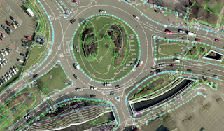
These surveys are conducted within the limits of a city for urban planning. These are required for the purpose of layout of streets, buildings, sewers, pipes, etc.
TOPOGRAPHICAL SURVEYING
Topography is defined as the shape or configuration of the earth’s surface. The topographic maps show not only the plan but also the elevations of the terrain. These surveys are required to establish horizontal locations of the various points as well as the vertical locations. Information pertaining to reliefs and undulations on the earth’s surface is generally shown in the form of contours of equal elevations. Cartography is the science of expressing graphically the knowledge of the earth’s surface and its varied features. Cartographic surveying includes all the operations leading to the production of topographic maps.
ROUTE SURVEYING
These surveys are special types of topographical surveys conducted along a proposed route for a highway, railway, sewer line, etc. The route survey is done along a wide strip. In general, the route surveying also includes the staking out and calculations of the earth work.
MINE SURVEYING
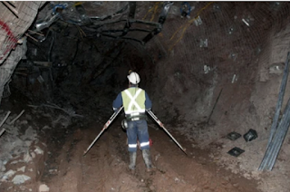
These surveys are conducted to determine the relative positions and elevations of mines, shafts, adits, bore holes, etc. for underground works. In general, mine surveys include both underground surveys and the related surface surveys. Mine surveys are used to plan the working of mines and to compute the volume of material in mines.
HYDROGRAPHIC SURVEYING
These surveys are conducted on or near the body of water, such as lakes, rivers, bays, harbours, Marine surveys are special type of hydrographic surveys. These cover a broader area near sea for offshore structures, navigations, and tides, etc. The hydrographic surveys consists of locating shore lines, estimation of water flow, and determination of the shape of areas beneath the water surface. It also includes the determination of channel depth, location of locks, sand bars, buoys, etc.
ENGINEERING SURVEYING
Engineering surveys are conducted to collect data for the designing and planning of engineering works such as building, roads, bridges, dams, reservoirs, sewers, and water supply lines. These surveys generally include land surveys, city surveys, topographical surveys and route surveys discussed above.
ASTRONOMIC SURVEYING
These surveys are conducted for the determination of latitudes, longitudes, azimuths, local time, etc. for various places on the earth by observing heavenly bodies (the sun or stars). The absolute locations of various points on the earth is obtained by astronomic surveys.
SATELLITE SURVEYING
These surveys are conducted to obtain intercontinental, inter-datum and inter-island geodetic ties all the world over by artificial earth satellites. These surveys are done by space agencies.
GEOLOGICAL SURVEYING
Geological surveys are conducted to obtain information about different strata of earth’s surface for geological studies. Geological maps are prepared depicting the details of the strata.
CONSTRUCTION SURVEYING
All the above mentioned surveys are conducted to obtain information required for preparation of maps, plans, sections, etc. After the plans have been prepared and the structures designed, the construction surveys is conducted. The points and lines are established on the ground, and the layout plan of the structure is marked on the ground. Stakes are driven for setting out. Thus construction surveys are the reverse of engineering surveys. Construction surveys are also called location surveys or setting out.
MISCELLANEOUS SURVEYING
- Archaeological surveying - These are done to unearth relics of antiquity.
- Military surveying - These are conducted to determine the routes and points of strategic importance.
- Gravity surveys. These are conducted to measure the intensity of the gravitational force at various points.
- General surveying - These are used to acquire and accumulate qualitative information and quantitative data for a specific purpose by observing, counting, classifying and recording according to the need. For example, soil surveying and traffic surveying


Post a Comment