PRIMARY DIVISIONS OF SURVEYING (StudyCivilEngg.com)
PRIMARY DIVISIONS OF SURVEYING
SUBJECT : SURVEYING
We have already discussed about the Introduction and History of Surveying (Click here to read). Primary division of surveying is made on the basic whether the curvature of the earth is considered or whether the earth is assumed to be a flat plane. The actual shape of the earth is an oblate spheroid. It is ellipsoid of revolution, flattened at the poles and bulging at the equator. The length of the polar axis is about 12713.168 km and that of the equatorial axis is about 12756.602 km, as computed by Clark in 1866. Thus the polar axis is shorter than the equatorial axis by about 43.434 km.
Relative to the diameter of the earth, the difference in the lengths of the two axes is a very small quantity, about 0.34%. The student’s understanding is greatly facilitated by assuming the earth to be an approximate sphere. Because of the curvature of the earth’s surface, the measured distances on earth’s surface are actually curved.
However, when the distances are small, compared with the radius of the earth, there is no significant difference between the curved distances and the corresponding straight line distances, and the curvature of the earth can be neglected. Surveying is thus primarily divided into two types:
- Plane Surveying
- Geodetic Surveying
WHAT IS PLANE SURVEYING?
PLANE SURVEYING
It is the type of surveying in which the curvature of the earth is neglected and it is assumed to be a flat surface. All distance and horizontal angles are assumed to be projected onto a horizontal plane. A horizontal plane at a point is the plane which is perpendicular to the vertical line at that point. The vertical line is indicated by a freely suspended plumb bob. A single horizontal plane of reference is selected for the entire survey of the small area. Thus the plumb bob lines at all points of the area are assumed to be parallel.
Plane Surveying can safely be used when one is concerned with a small portions of the earth’s surface and the areas involved are less than 250 sq. km or so. It is worth noting that the difference between an arc distance of 18.5 km on the surface of the earth and the corresponding chord distance is less than 10 mm. Further, the difference between the sum of the angles of a spherical triangle having an area of 200 sq. km on the earth’s surface and that of the corresponding angles of the plane triangle is only 1 second. In plane surveying, the angles of polygons and triangles are considered as plane angles.
WHAT IS GEODETIC SURVEYING?
GEODETIC SURVEYING
It is the type of surveying in which the curvature of the earth is taken into consideration, and a very high standard of accuracy is maintained. The main object of geodetic surveying is to determine the precise location of a system of widely spaced points on the surface of the earth. The points so located are used as control station of the primary surveys. The secondary surveys of less precision are connected to these control stations.
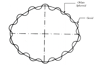
In geodetic surveying, the earth’s major and minor axes are computed accurately and a spheroid of reference is visualised. The spheroid is a mathematical surface obtained by revolving an ellipse about the earth’s polar axis. The earth’s mean sea-level surface which is perpendicular to the direction of gravity at every point is represented by a geoid. Because of variation in the earth’s mass distribution, the surface of the geoid is irregular.
However, if the irregularities of the surface are neglected, the geoid can be very closely approximated as the spheroid. The dimensions of the spheroid are selected so as to give a good fit to the geoid over a large area (Displayed in below figure). Thus an imaginary surface representing mean sea level extending over the entire surface of the earth is represented by a spheroid.
ALSO READ INTRODUCTION & HISORY OF SURVEYING : CLICK HERE
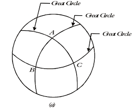
Below figure (a) shows three points A, B and C on the mean surface of the earth. The lines AB, BC and CA are the arcs of great circles passing through the centre of the earth. A great circle is formed by the intersection of a plane passing through the centre of the earth. The figure formed by joining three points A, B and C is a spherical triangle.
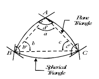
Figure (b) shows the enlarged view of the spherical triangle. The spherical angles a°, b° and c° are larger than the corresponding angles a, b and c of the plane triangle ABC (shown dotted). In geodetic surveying, the distances AB, BC and CA are determined from the spherical triangle using spherical trigonometry, whereas in plane surveying, these distances are obtained from the plane triangle using plane trigonometry.
To summarise about the Plane Surveying and Geodetic Surveying,
Plane Surveying
- It is used for relatively small areas.
- A curved line on the surface of the earth is considered as mathematically straight.
- The directions of the plumb lines at various points are assumed to be parallel to one another.
- The spherical angles are considered as plane angles.
- The standard of accuracy is lower than that in geodetic surveying.
Geodetic Surveying
- It is used for large areas.
- It is used for establishing precise points of reference or control points.
- The surface of the earth is considered as curved.
- The directions of plumb lines at various points are different. The earth’ s mean sea level is perpendicular to the direction of gravity indicated by plumb bobs.
- The standard of accuracy is very high. Very precise instruments are used.
Related Posts:


Post a Comment